• Skip to primary navigation
  • Skip to main content

Friends of Leckhampton Hill and Charlton Kings Common

  • Home
  • Programme
    • Locations
  • What’s New
  • Nature Diary
  • Site Description
    • Drone Survey Images
    • Access & Parking
    • Recent History
    • Plants & Trees
    • Birds
    • Butterflies
    • Butterfly Surveys
    • Bats
    • Other Animals
    • Conservation Grazing
    • Cotswold Stone Walls
    • Historical Archaeology
    • Industrial Archaeology
    • Geology
    • Views
  • FOLK Work Parties
    • Work Party Plans/Reports
    • Insurance
    • Health & Safety
  • Activities
    • Walking
    • Mobility Scooter Route
    • Cycling
  • Join Us
  • About Us
  • Contact Us

Drone Survey Images

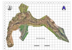
A drone photographic survey was undertaken over Leckhampton Hill and Charlton Kings Common in April 2018.  The resulting 2-D photomosaic is shown below.  Unfortunately we can only display a medium resolution image here but we do have much better high-resolution images that allow us to see things in much more detail.

FOLK is now using this information to map out and record various features on the site, e.g. where gorse exits, and is using this to improve the management and planning of work on the site.

The drone survey and data collation was performed by Steady Hawk (http://steadyhawk.com/) from Bristol under contract to Cheltenham Borough Council with part funding by FOLK.

  • Drone Survey Images
  • Access & Parking
  • Recent History
  • Plants & Trees
  • Birds
  • Butterflies
  • Butterfly Surveys
  • Bats
  • Other Animals
  • Conservation Grazing
  • Cotswold Stone Walls
  • Historical Archaeology
  • Industrial Archaeology
  • Geology
  • Views
  • Committee Members Page
  • Newsletters
  • Lottery
  • Documents
  • Links
  • About Us
  • Contact Us
  • Join Us
  • We're on Facebook

Website created by Made in Trenbania