If you have a spare minute or 16, you might like to see a YouTube video of the new path network on Leckhampton Hill/CKC taken with a new 360 camera. One of our Cotswold Warden buddies, John Shaw, on behalf of the disabled ramblers, is carrying out a series of videos highlighting easier access sites throughout the Cotswolds. This is supported by Cotswold National Landscapes who financed the camera and are helping John on his journeys. He is using a hired tramper and shows how easily he can traverse the site using the new paths we have recently installed. There is a surprise addition at the end!
Please note that since this video was recorded, access to the trail from Brownstones quarry has been improved.
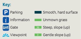
This route is a mix of hard or grassy and mostly flat surface accessible by any reasonably sturdy mobility scooter. Can be muddy after rain. Gradients do not exceed 10% and there are no significant cross-gradients. There are gateways along the way but the gates have generally been removed but where this has not been possible their closing mechanisms have been modified to make them easier to open.
The route was designed and executed by the Cotswold Voluntary Wardens as a 50th Anniversary project with the help and support of the Leckhampton Hill Ranger (Cheltenham Borough Council), FOLK and the Disabled Ramblers. Please note: Some of the routes may be difficult or impassable in bad weather and after rain. Always wear appropriate clothing and footwear and beware of traffic. The Cotswold Conservation Board cannot accept responsibility for accidents or difficulties experienced by users of these routes.
Distance: The route is 2.25 miles/3.6 kms with ups and downs of 58m/190ft.
Route: The route is as indicated in the map and description below. It is fully waymarked with these signs  .
.
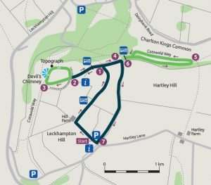
Start from the Brownstone car park in Hartley Lane. Access from Leckhampton Hill Road or the A435, Seven Springs roundabout. From the car park turn right and take the track past the barn, continue through a gateway onto a tarmac path to meet a cross path at ![]() .
.
Turn left and shortly go through a gateway to find an information board ![]() . Follow the tarmac path through a gap in the earthwork and pick the leftmost or centre path ahead to proceed to find the Cotswold Way
. Follow the tarmac path through a gap in the earthwork and pick the leftmost or centre path ahead to proceed to find the Cotswold Way ![]() as the ground falls away. The earthworks are remnants of an ancient hilltop settlement. Now turn right uphill along the scarp edge to a topograph, from here leave the Cotswold Way to make your way back towards the gap in the earthwork and point
as the ground falls away. The earthworks are remnants of an ancient hilltop settlement. Now turn right uphill along the scarp edge to a topograph, from here leave the Cotswold Way to make your way back towards the gap in the earthwork and point ![]() .
.
From ![]() continue along the path with the fence on your right to go left through a gateway
continue along the path with the fence on your right to go left through a gateway ![]() rejoining the Cotswold Way and continue up a short sharp rise to another gateway. Now take the broad path alongside the wall with a second information board. You may meet docile but inquisitive cattle on this stretch.
rejoining the Cotswold Way and continue up a short sharp rise to another gateway. Now take the broad path alongside the wall with a second information board. You may meet docile but inquisitive cattle on this stretch.
Towards ![]() the path narrows at a Cotswold Way marker post, then forks. Take the right fork looping gently round through a copse to begin your return to
the path narrows at a Cotswold Way marker post, then forks. Take the right fork looping gently round through a copse to begin your return to ![]() . Passing through the gateway now go ahead through
. Passing through the gateway now go ahead through ![]() down a hard path back to the start, alongside a disused brownstone quarry. At
down a hard path back to the start, alongside a disused brownstone quarry. At ![]() emerge onto a road and turn right to return to the car park. Here you will find further information boards.
emerge onto a road and turn right to return to the car park. Here you will find further information boards.